
Its 2020 and everyone is using google for everything. Google knows more about us than we know about ourselves.
I remember sitting in a college e-commerce class when google first came out. NO one took it seriously, I know I didn't or I would have bought stock in it.
So what does google have to do with flood insurance?
As we mentioned google probably has more data than any other service out there.
Private flood insurance and the National Flood Insurance Program use different resources for determining flood insurance rates.
One of the benefits of private flood insurance is the advancement in technology they use in determining flood insurance rates.
While the National Flood Insurance Program or FEMA looks at a parcel many times they can not tell if a structure is elevated or not. So you may have a structure that sits 50 feet high but FEMA still thinks it is in the special flood hazard area. This is one reason why elevation certificates are required so many times.
So what is the private flood insurance approach to this? Private flood insurance uses many tools when mapping a risk. One thing they look at to determine the rating for a risk is location. Generally google earth is used to help determine this rate.
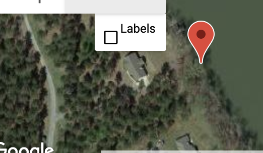
Google earth can be a great tool when locating a property. However if you have multiple structures on a property it may try to show the wrong structure. Let's look at an example of where this might happen. Imagine you have a lake house on Smith Lake in the Cullman or Jasper Alabama or maybe Lay Lake in Shelby, or Lake Logan Martin in the Pell City area. If you live on the lake you probably have a boat house as most lake home owners do.

This could cause a major impact on your flood insurance if you are not careful. As the photo below shows this boat house is much closer to the water than the main house.
So as you can imagine you will probably pay more for private flood insurance based on location.
So what exactly can you do to make sure this is accurate?
When getting a private flood insurance quote from The Flood Insurance Guru or any insurance agent ask for a picture of the map for accuracy. What you want to look at is where the red pin drop is at. It needs to be located on the structure that you will be insuring.
We recently saw where it was a difference of almost $1200 a year for the property owner.
As you can see you could be overcharged for flood insurance without even realizing it. Imagine if this error occurred for multiple years that could be a lot of money out of your pocket.
So can you get some of this premium back?
Maybe or maybe not
It depends on the private flood insurance company that you are dealing with, generally it can be difficult to get flood insurance refunds on prior policies.
So maybe you think you are being over charged or want to verify that your flood insurance is accurate then make sure to click here for us to verify it for you.
You can also visit our website or YouTube channel where we do daily flood education videos.