
Georgia is about to see a lot of changes with their flood maps for different communities just this month. Let's talk about the good, bad, and ugly changes coming to Putnam County with its new flood insurance rate maps (FIRMs) on January 26th, 2023.
New Flood Maps for Georgia
As flooding constantly changes and floodplain devolvement increases, we can easily expect some changes to flood zones for property owners across the country. This is especially true for multiple counties in Georgia such as Morgan, Hancock, and Putnam County.
READ MORE: Morgan County Flood Map Update for January 2023.
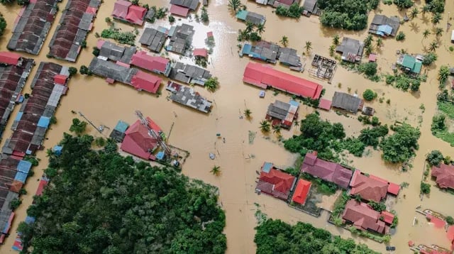
We have seen how some cities in Georgia will easily get flooded with just 1 to 4 inches of rain. Just a few days ago, this was the case for some parts of the state after continuous bad weather dumped around 2 to 4 inches of rain in the course of 24 hours. This weather event alone caused multiple road closures and one road in Athens even opened up a sinkhole that swallowed a car whole.
This recent incident just shows how prone flooding the state can be. Such events can also impact how the government approaches flood risk and even flood zones. So let's talk about the changes to flood zones in Putnam County.

The Good
First, let's look at the good impacts of this new flood insurance rate map (FIRM) for Putnam County. It's important to note here that the current flood map Putnam County is using was from 15 years ago. You can easily say that this update to understanding the risk of flooding for the county is long overdue.
To understand the good changes, we first need to talk about the movement involved in properties impacted by this change in this new flood hazard map. When we say "good", we talk about the "In To Out" movement. This means that properties impacted that are in the special flood hazard area (SFHA) or high-risk areas will be mapped into a lower-risk zone. Some would call this moving into flood zone X.

For Putnam County, around 1,312 properties are going to experience this "In To Out" type of movement. One of the biggest impacts of this is that flood insurance requirements will no longer apply to the property.
The Bad
Now, let's talk about the exact opposite of this movement which involves the "Out To In" movement in this preliminary flood map from FEMA.
We call this a bad change because this means that 607 properties in Putnam County will be moved from a low-risk area and mapped into a high-risk area like Flood Zone A. Properties in the special flood hazard area (SFHA) will start to see mandatory flood insurance requirements. This is generally set by your mortgage lender and the Federal Emergency Management Agency (FEMA).
Although being in a high-risk flood zone won't really impact your premium rates, this can easily add up to your budget and expenses especially if you don't already have a flood insurance policy active with your home.
The Ugly
Lastly, we have what we call an ugly change. This is where properties will be moving "In To In" wherein property owners that are already in the SFHA will be moved into a higher-risk flood zone. For example, this could be the same as being in flood zone A and being mapped into a flood zone AE.

From FEMA's flood studies and this upcoming flood map, we can see that at least 5,055 properties out of 19,000 properties will be experiencing this change. That means that at least 26% of structures in Putnam County will be experiencing the "In To In" movement.
If we were to add up the bad and ugly changes, we see that around thirty percent of homes in Putnam communities will be required to carry flood insurance.
How To Fight Flood Map Changes
Changing Your Flood Zone
Let's just say you have a property that's mapped into a low-risk flood zone like flood zone X, this doesn't mean that that building will stay in that zone forever. This is especially true as flooding impacts how flood insurance rate maps (FIRM) work.
Sometimes, when a flood insurance rate map update comes to your community, this could mean that you might see your property get moved into a high-risk area like flood zone A or flood zone AE. Having your property or building mapped into a high-risk flood area generally results in a mandatory purchase of flood insurance.
To see your revisions to your community's flood maps, you can CLICK HERE to visit the official website for FEMA flood insurance rate map (FIRM) changes.

This requirement might come from your mortgage lender or the state law itself such as the Federal Emergency Management Agency's (FEMA) standards. But, what if you know that your property shouldn't be in a high-risk flood zone? How do you fight these changes?
This is where what's called a Letter Of Map Amendment (LOMA) comes in to save the day.
Letter Of Map Amendment
A Letter of Map Amendment (LOMA) is an official document that's issued by FEMA to process the change of a flood zone designation for a property.
An elevation certificate will show a more accurate representation of your property such as its risks from flood water, base flood elevation, its exact distance from your lowest habitational floor, and other relevant information. A LOMA is achieved after a successful application for a Letter of Map Change (LOMC) thru FEMA's official website.
It helps to have the necessary information and documents when applying for a LOMA. One of the helpful supporting documents you can provide is an elevation certification.
Although elevation certificates are no longer required — especially with the recent update to the National Flood Insurance Program (NFIP) and Risk Rating 2.0 — this can really help a lot in proving the validity of your request to be mapped out of a high-risk area.
Flood REMINDER
So these are the good, the bad, and the ugly changes coming to Putnam. When it comes to actual flood risks, the reality is that even low-risk flood zones can be flooded too. This also means that getting a Letter of Map Amendment (LOMA) done won't guarantee that your home no longer has flood risks.
This is why we still encourage property owners to get flood insurance coverage for their property. A single flood policy will be able to provide building and contents coverage, so both the structure and your personal property inside it will have flood protection.
If you have questions regarding flood zones, flood insurance, or anything flood-related, click below to access our Flood Learning Center to get your answers.

Ready to start simplifying your flood insurance? Just follow these three simple steps:

Topics:


